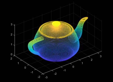
Point cloud and 3D image
Date:2020-03-26
Three-dimensional image is characterized by three dimensions of data, including width, height and depth. It can be expressed in three forms, i.e. depth map (expressing the distance between the object and the camera in grayscale), geometric model (created in a CAD software) and point cloud (3D scanners collect many points on the surfaces of objects). Point cloud data is the most common and basic way of expressing 3D image.

A point cloud is a massive collection of points that express the characteristics of the surface of a target object. It is often produced by 3D scanners, such as Tanso and Handysense from Revopoint. Each point contains three coordinates to position it in space and also RGB and/or intensity information. The valuable information is hidden in the point cloud and needs to be extracted. The process of extracting the information in the point cloud is 3D image processing.
Point clouds can be used in many applications, including 3D model creation, measurement, quality inspection, and mass customization.
Point clouds are often converted to polygon mesh or triangle mesh through a process commonly referred to as surface reconstruction.
A high-quality point cloud is very close to the original object, in other words, it keeps as much details of the object as possible.
Visit https://sketchfab.com/Revopoint3d for 3D point cloud samples.
Next:The Era of 3D Machine Vision
Hot news
-
1. Point cloud and 3D image 508

2. What is 3D camera 374

3. Why do Companies Turn to 3D Machine Vision Instead of 2D? 268

4. The Era of 3D Machine Vision 254

 Change
Latest News
-
1. Point cloud and 3D image 508

2. Why do Companies Turn to 3D Machine Vision Instead of 2D? 268

3. The Era of 3D Machine Vision 254

4. What is 3D camera 374

 Change


